![]()
Bruce G. Marcot
The Devil's Triangle ... that immense oceanic expanse that lies within the triangle of Bermuda, Miami, and Bahamas ... has been blamed for the disappearance of more planes and ships than most other spots on Earth.Theories of this supposed phenomenon have included: mysterious gravitational or magnetic vortices; the release of immense amounts of benthic gases that neutralize boyancy; bad weather; and exaggeration of the facts.
If there is anything to the mystery, maybe the answer lies in several causes.
One such cause has been attributed to rapidly-changing weather conditions, hampering visual flight lines. This theory says that at times atmospheric haze conditions over the ocean in this region can mask the horizon line, making it impossible to discern ocean from sky.
... I know this is so, because I have seen it.
 On
March 13th (appropriately), 1991, I flew in a small 4-seater Cesna that
arced from Miami airport across the southern fringe of the Devil's Triangle
-- also called the Bermuda Triangle -- to the tiny town of San Andros on
the mostly uninhabited Andros Island, Bahamas. There was only the
pilot, my wife, and myself; I flew in the copilot's seat up front.
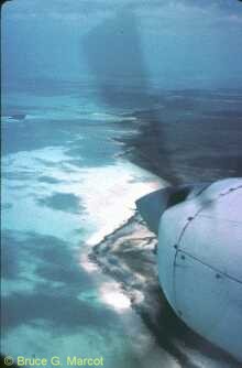
During the last third of the flight, which up to that point had been in
brilliant sun with spectacular turquiose reefs below, a sudden haze appeared
on the horizon. In an instant, we were flying not within clouds but
through a most odd haze. I could clearly see the ocean below, but
it graded into gray where the horizon should be, and there was no discernable
horizon line at all.
On
March 13th (appropriately), 1991, I flew in a small 4-seater Cesna that
arced from Miami airport across the southern fringe of the Devil's Triangle
-- also called the Bermuda Triangle -- to the tiny town of San Andros on
the mostly uninhabited Andros Island, Bahamas. There was only the
pilot, my wife, and myself; I flew in the copilot's seat up front.
During the last third of the flight, which up to that point had been in
brilliant sun with spectacular turquiose reefs below, a sudden haze appeared
on the horizon. In an instant, we were flying not within clouds but
through a most odd haze. I could clearly see the ocean below, but
it graded into gray where the horizon should be, and there was no discernable
horizon line at all.
Here's an extract from my journal notes of the following day, after we safely landed on Andros Island:
Flying into Andros Island from Miami yesterday was remarkable -- touched the southern edge of the Bermuda [Devil's] Triangle. The horizon was undefined and vague, filled with low-elevation clouds and impossible to delineate. I can image how, flying into the triangle with instruments out, one could intercept the ocean without seeing it coming.At one point, flying east-southeast at 3500 feet altitude, we climbed to 5500 feet to skim over some low cumulus clouds, then dropped back to 3500 feet ... during the easy descent, at a rate of only 500 feet/minute, I could have sworn we were level and flying straight into the (undefined) sea-sky horizon. But we were not.
And here is the actual unretouched photograph I took
straight forward, of the horizon line that day out the front of the Cesna
windshield ...

... yes, it is all gray with no discernible features.
And it was taken when the ocean below was clearly visible.
* * *
The "Devils Triangle" was identified on the ancient map Mappa Aestivarum Insularum alias Bermudas dictarum, from Amsterdam, by Abraham Goos, ca. 1626 (original map size 60 x 72 cm.):
These Ilands, formerly called the Bermudas, now the Sommer Ilands, shunned by travellers, as most dangerous, and seldome seene by any, except against their wills, reputed to be rather a hold and habitation of Devils, then any fit place for men to abide in, were discovered in the years 1609.from:
http://www.bell.lib.umn.edu/historical/Hist.html
The James Ford Bell Library of Historical Maps
![]()
Back to the Science Mysteries Page
Back to the Knowledge Plexus Page