Pluto on Earth
All terrestrial photos taken by and © Bruce G. Marcot.
Patterned Ground
It is well known that tundra landscapes in the high arctic often take the form
of what is called "patterned ground," which looks like interlocking
polygons of pentagonal and hexagonal areas.
Patterned ground results from freeze-thaw of the "active layer," which is the top several inches to a few feet of the surface that thaws then freezes in annual cycles, below which is permafrost -- permanently frozen subsurface.
First, here are a few photos of mine of patterned ground I took in the high arctic of Alaska:
Outside Deadhorse, Alaska, next to Prudhoe Bay, by the Beaufort Sea of the
Arctic Ocean:

Along the coastline outside Barrow, Alaska, along the Chukchi
Sea of the Arctic Ocean:
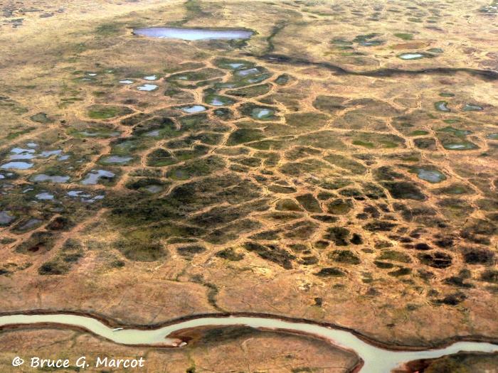
In Selawik National Wildlife Refuge in western
Alaska:

In Noatak National Preserve in northwestern
Alaska:
Now, compare the above images to this image of the surface of Pluto,
photographed during the New Horizons NASA mission,
which exhibits a remarkably similar patterned-ground design:

Might this be evidence of some freeze-thaw cycle of at least the subsurface?
If so, where might Pluto get
its energy and heat? My speculation is that, because Pluto and its primary
moon Charon, are locked in what is essentially a double-planet orbital
configuration, there may be enough heat generated from tidal forces that ebb and
flow over the course of their mutual orbits.
- - - - - - - -
My thanks to astronomer Brad Smith for also supplying these two NASA photos of
"patterned ground" also having been discovered and photographed from
the surface of Mars:

