Mars on Earth
All terrestrial photos taken by and © Bruce G. Marcot.
Updates added to end of page.
CONTENTS
Slope Slips
In a very remote corner of the Alaskan arctic is a place
called Noatak National Preserve, which is a little-known and seldom-visited unit
of the U.S. National Park Service. In summer of 2013 I conducted an aerial
photographic study of the region from the back seat of a Cessna 185
single-engine airplane.
In a northern corner of the park I captured the following striking images of dark streaks caused by slope slips and rockslides:
(Click on all images for larger versions.)


Now compare the above images with similar-appearing slope-slip patterns photographed by NASA's Mars Reconnaissance Orbiter, on the surface of Mars:


Left: Original image and orientation.
Right: Image flipped and changed to negative; compare this to
the first image I took in Alaska, above.


I speculate that these landforms on both Earth and Mars were formed by similar geomorphic events, mainly slope failure in a mostly arid and cold environment, particularly on very steep gradients. Perhaps the initial impetus for the slips was subsurface ice, as has indeed been found on Mars. Remember, the Earth sites are in the high arctic.
And here is the location (noted by the red dot) of the photographs I took in northwestern Alaska:

References:
Hooper, D.M., C.L. Dinwiddie, and R.N. McGinnis. 2012. Meltwater-induced debris flows on cold-climate aeolian dunes and the implications for analogous processes on Mars. Third International Planetary Dunes Workshop. 7046.pdf. 2 pp.
Reiss, D., G. Erkeling, K. Bauch, and H. Hiesinger. 2010. Evidence for present day gully activity on the Russell Crater Dune Field, Mars. 41st Lunar and Planetary Science Conference. 2152.pdf. 2 pp.
Update: I appreciate the feedback I received on the above images and text from astronomer Brad Smith, who suggested that the "slope slip" images from Mars are features called "recurring slope lineae" or RSLs, which are actually streams of briny water released seasonally from the inner walls of certain craters. These, according to Smith, are different in origin than the Earthly features which result from mass wasting caused by fluvial (running water) or aeolian (wind) erosion causing the slopes to exceed the angle or repose (the angle at which gravity overcomes friction, and the slope slips). He goes on to note that spectral analyses of the Martian RSLs reveal they contain perchlorates and other salts found on the Martian surface; such salts allow water to remain liquid at temperatures of -20C, well below the usual freezing point of -0C. Further, Smith notes that it is the chemical analyses of the Martian RSLs that provide the evidence for water on Mars, by the supposition that this briny water flows down the slopes of some crater when summer temperatures exceed -20C.
Desert Pavement
When wind blows across a desert floor, it scours the rocks and surfaces into what geologists call "desert pavement."
A well-known example, and analog to the surface of Mars, is found in the ultra-dry Atacama Desert of northern Chile.
Compare my photos of the Atacama Desert here ...


... with NASA photos of the surface of Mars, as taken by their rover missions:


The same aeolian (wind) processes occur
on both planets.
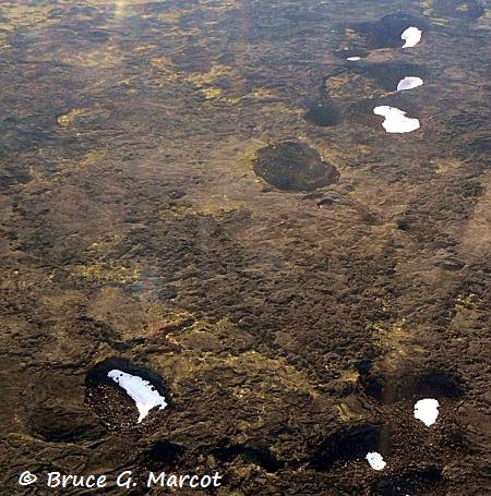
Lava Pits
In northwestern Alaska, on the Seward Peninsula of the Bering Strait, lies an unexpected, vast lava field called the Imuruk Lava Beds Landscape (see my Ecology Picture of the Week episode on this remarkable area).
As I flew over this remote and inaccessible region, I photographed a region with various pits apparently resulting from collapse of lava tube roofs.
Snow and ice has remained in the sheltered, shaded recesses.
These formations seem remarkably similar to the lava and ice pits that have been photographed on the surface of Mars.
First, my photo of the lava pits of Imuruk Lava Beds, Alaska:
And compare the above photo to the lava pits on Mars:

Also check out lava tubes on the moon ... !
![]()
Barchan Sand Dunes
Mars is famous for its shifting sands ... some of which form "barchan" sand dunes, which are crescent-shaped dunes with a very steep slip face.
Barchans are also fairly common in some deserts of Earth, such as the Gobi Desert of southern Mongolia. Below are photos I took there, in the area of Moltsog Els Dunes:


Now compare the above Earthly barchans to those on Mars, courtesy of NASA/JPL:


![]()