|
|
Rift
Valley of Eastern |
|
|
Click on images for larger versions
|
|
Rift
Valley of Eastern |
|
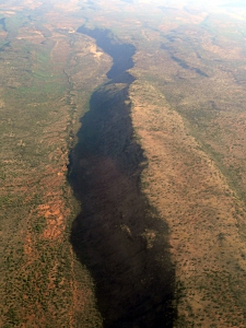
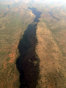
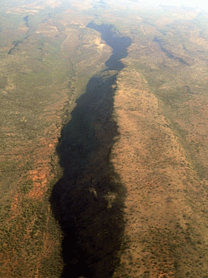
Rift Valley escarpment, Kenya, eastern Africa |
Credit & Copyright: Dr. Bruce G.
Marcot
|
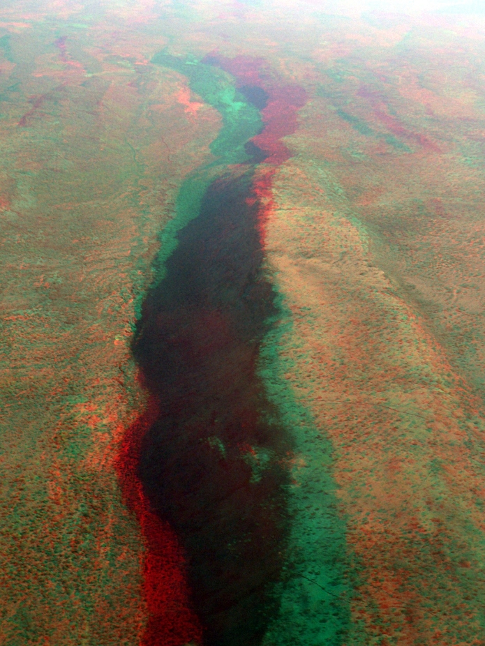
Explanation: Break out your red-blue 3D glasses! This is a major escarpment of the Rift Valley of eastern Africa. Running some 6000 km (3700 miles) long, the Rift Valley is the junction of two major tectonic plates. Gigantic fault lines have lifted and offset major parts of Earth's crust, forming plunging valleys and high escarpments and cliffs such as those shown here. The Rift Valley is home to the most ancient of human fossils ever found. It is ringed by ancient volcanoes and contains a number of major lakes and wetlands of eastern Africa including Lake Victoria, Lake Malawi, and many others.
As I was flying along, photographing the landscape below, I realized that I could create three different ways to express the immensity of the landscape in 3D. 1. Anaglyphs. The first method entailed taking two photos from slightly different angles at the same altitude, and creating what is known as an anaglyph from them. Anaglyphs are viewed with traditional red-blue 3D glasses (don't have yours? you can find them on the web). The two photos I used are shown below (in smaller size). You can create an anaglyph image in Photoshop (although I used the excellent freeware program Paint.net) by following instructions found on the web. And here is a larger version of the anaglyph image I created of the Rift Valley scene. It shows more detail than the main image present above. 2. Stereo pair. This method takes the two basic images used for creating the anaglyph but shrinking them in size and positioning them side by side. You then squint and cross your eyes and otherwise stare at them until them merge together, forming a 3D image. Try it here:
If you are having trouble merging the above images, you can try smaller sizes:
This is a very old-fashioned way to produce 3D images. 3. Animation. The following 2-image animation is a simple way to demonstrate the depth of this image. Of course, multi-frame animations of this type are called movies, eh?
|
Next week's picture: Earth's Oldest Trees
< Previous ... | Archive |
Index |
Location | Search | About EPOW | ... Next >
|
|

Author & Webmaster: Dr.
Bruce G. Marcot, Tom Bruce
Disclaimers and Legal
Statements
Original material on Ecology Picture of the Week ©
Bruce G. Marcot
Member Theme of Taos-Telecommunity

